Showing posts with label Ben Corner. Show all posts

Monday, August 24, 2009

Lakes, Lutherans, and Mountains

So Brandon and I saw the summer was wearing thin and we still were needing to climb a big mountain. With no volcanoes in the picture we decided to go for a remote big boy: Mount Fernow, third highest non-volcanic peak in Washington, lord of the Entiats, at 9249 feet (but who's counting right?). I have to make it sound dramatic because no one's really heard of it. Here's an idea of what we were dealing with:

The trip started with a ride up Lake Chelan on a Ferry. We got off at Lucerne, about 4/5th of the way up the lake and caught the bus to Holden, an mining village turned Lutheran retreat. Being the only Mormons within 50 miles we decided to lay low until we could retrieve our bags and head up the trail. That trail got us to this nice meadow. From there we had to go up and over the saddle you can see in the background.The other side of the saddle is the dramatic headwaters of the Entiat river. We found a soft, flat place to pitch our tent. The view wasn't bad either:

The next morning we set out at 4am and arrived at the summit just after dawn. If you're not in on the secret, the best time to do anything outdoors is at dawn; this was no exception. The views were amazing in the hazy dawn glow. Here's Brandon with the North Cascades beyond.

We had to run back down to be back in Holden to catch the bus at 1pm. There's only one bus a day. The fact that Bri didn't murder me is proof we got back in time.

Sunday, July 19, 2009

Goat Rocks Fiasco

It started with a bargain. Bri came up with it: Ben finishes reading the Twilight series (he was bogged down in book two) and Bri goes backpacking with Ben in the Goat Rocks. Deal. In case you're wondering why the Goat Rocks, it's where the vampires go hunting in book one. It was also on my list of places to check out. In case you're wondering what the Goat Rocks are, they're a high volcanic ridge just south of White Pass in south central Washington. The next major development came a few weeks later when we found out Bri was pregnant. But the deal had been made. That brings us to last Friday, when we set out from Conrad Meadows into the heart of the wilderness. Here's Bri with the highest point of the Goat rocks in the background. That was our destination.
So Conrad Meadows is apparently the largest sub alpine meadow in Washington. Take that for what it's worth. The first section is actually range land for cattle. After a few miles you get into the Goat Rocks Wilderness. Bri was stoked.It was a hot day. It was 102 when we passed through Yakima. Luckily the altitude, time of day, and shade were on our side. The mosquitoes were not on our side. Despite applying bug spray Ben ended up with 76 bites, mostly on the back of his upper arms, where he missed with the bug spray. Bri escaped with only a handfull. After a long hike with plenty of elevation gain we came to this nice cliff where we camped the night. What a view! Did we mention this was Bri's first backpacking trip ever? Another first for Bri was drinking water straight from a glacier (ok, ok, its technically a permanent snow field). Here's Ben refilling our water supply. Around our campsite we stumbled upon an entire herd of what Ben believes were mule deer. There were about ten that we saw, including big males and babies. They checked us out for a minute then ran off. We were the only people out there. Speaking of animals, Bri proved to be like a mountain goat, only much more attractive. Here she is tackling some snow. That women is four months pregnant!
Let's be honest. This trip was hard on Bri. Her bag was only about 15 pounds, but Ben ended up carrying it about a third of the way, including almost all the uphill parts. Here's what that looked like as we arrived at Surprise Lake on Saturday morning.
Our grand total in mileage was about 15 or 16 miles. It was a great time. Next time we'll do something a little shorter when Bri is a little less pregnant, though.

Monday, May 25, 2009

Index Bash

I'd been saving up for this one since October; Mount Index the imposing sentinel of the Skykomish Valley. It's an impressive sight from Highway 2. Here's the view from our pre-dawn approach.

In addition to the impressiveness of the objective, this trip require a particularly hardcore route to the summit. It started with a six-mile mountain bike. Here's what that looked like.
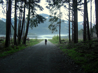
After that there was a three-mile stretch on an abandoned logging road. It was more like a jungle bushwhack with plenty of washouts to boot. See for yourself. Yes Brandon and Chris are in this picture. From there it was up onto the alpine slopes where the snow was deep, the skies blue, and the views incredible. The one downer on the trip were the avalanche chutes blocking all routes to the actual summit. But it's hard to complain when we got in 20 miles with 4,500 feet of elevation gain and a whole lot of awesome terrain.


Tuesday, March 17, 2009

Amapukis Mountain

Brandon and I went cross-country skiing this morning. He puked in the first quarter-mile. That's a good summary of how things went. There was lots of powder. That's a good thing for downhill skiing, but when you're working against gravity not so much. I didn't see my skis the whole time. By the time we were about two-thirds up Amabilis Mountain the powder was waste deep, even in snowshoes. The deep powder prevented a nice downhill run back to the car. At least the early turn around allowed us to get home just a little after lunch.
Did I mention the near white-out conditions?

Thursday, January 29, 2009

A Walk in the Winter

Brandon and I set out for some snowshoeing last Saturday. We went to Snoqualmie pass for a half-hearted attempt at Snoqualmie Mountain. It turned out to be a bit too icy to make it up without crampons. But we did make it above the clouds for some awesome views. We also got in some snowshoeing down where the snow was softer. The first picture is me looking at chair peak. Below is Brandon in a sub-alpine wonderland.


Sunday, October 19, 2008

Mount Stuart

For our last climb of the year Brandon, Chris, and I climbed Mount Stuart. Before you say "I've never heard of that mountain," let me ask if you have ever driven on I-90? Around Ellensburg have you ever looked to the north and seen this?

Well, if you have, on the left you were unknowingly viewing the second highest non-volcanic peak in Washington, as well as one of the most prominent peaks and the largest block of granite in the lower 48: Mount Stuart. It was a handy 8,000 foot plus elevation gain. Here I am on the approach.
We camped at the base of the mountain and got started a few hours before dawn. Here is the sunrise from high on the mountain (Brandon is hidden in the foreground).

Unfortunately that nice cap of white in the picture of me and the mountain proved to be about an inch of ice on bare rock dusted with snow. So we had to turn back just before the summit. But that was more than made up for by the beautiful surroundings; including these awesome alpine larches, the only evergreen tree that's not (they turn gold in the fall and lose their needles).Wow!

Wednesday, September 24, 2008

Big Day at the Wilson House

Today, September 24th, was a big day here for two reasons. First and for most, it was Violet's 6-month birthday. We noticed she bares a striking resembelance to Livingston, the cabbage patch kid. What do you think?


Also, it just so happened that today I took and passed my general exam. What does that mean? I gave a 45 minutes presentation about what I plan to use for my doctoral thesis to a committee of professors who then grilled me on it for an extra 45 minutes. It also means I'm on pace to finish my PhD in one year. Violet was so excited by the news!

(Taken today)

Wednesday, August 27, 2008

Princess Master

So I was watching the girls a few nights ago when I decided to introduce Ginny to Google. I typed in "Princess" and did an image search. The first image was a group of Disney princesses from Disney.com. She started rattling off names so I decided to test her princess prowess. Luckily I had a camera on hand...


Not bad, considering she's never even seen Snow White or the Little Mermaid. I'm not sure how she knew those...

By the way, I climbed this on Saturday with Mike from work. It's called Del Campo. More photos here.

Saturday, July 26, 2008

On Top of Oregon

This is Mount Hood. It's the tallest mountain in Oregon, towering more than 11,000 feet over Portland and the Columbia Gorge. Why not climb it?

This picture is from Trillium Lake, where we camped the night before. This spot is so scenic I was able to snap this picture while talking to Bri on my cell phone. We (myself, Brandon, our friend Chris, Ashley's dad Dave, and his friends Matt and Ben) started up the mountain at 6:30am. The first two-and-a-half hours were spent walking up through Timberline Ski Area, which is open year-round. Here I am at the top of the ski area next to the last out-of-bounds markers. In case you haven't noticed, one of my hobbies is attempting to make myself look cooler than I am using photography.

The going was pretty slow. We finally reached the crater. I wasn't aware Mount Hood had a crater because from most angles it looks like a sharp point. However, it does indeed have a crater that is blown out on one side, like Saint Helens, only much smaller. Here's a tour...


After ascending above the fumaroles and up what's called "the Old Chute," we made it to the summit. There was almost no wind and the views were spectacular! Here I am looking out across the Columbia river at Mount Adams in Washington. In addition to Adams, we had great views of Saint Helens, Rainier, the Goat Rocks, Mount Jefferson, all Three Sisters, Broken Top, and Diamond Peak.

After a while on the summit it was down the chute, out of the crater, a glissade (sliding on one's butt) to the ski area, and a quick stroll down to the parking lot: Eight hours up, three hours down. This is Brandon descending down the chute into the crater. There's Crater Rock and some very stinky fumaroles (vents spewing out sulfurous gases).

All-in-all this was an epic climb. Except for the chute at the end, there was nothing too challenging. It was mostly just endurance. However, even endurance isn't really necessary to climb Mount Hood. Most climbers we passed took the chairlift. Cheaters!

Sunday, June 29, 2008

Checkin' the Mail

Is it ironic, sarcastic, coincidental, facetious, or just plain common sense? Whatever it is, the highest point on Mailbox Peak is in fact a mailbox. I went up to check it out with a friend from work on Saturday. What type of mail is in the mailbox? Well, you'll have to climb the 2.5 mile "trail" with 4,000ft of elevation gain to find out.

Sunday, June 22, 2008

The Ash, the Ice, the Glory

So I decided to climb Mount Saint Helens. I duped my brother-in-law into going with me by claiming that "it's just like Mount Si, just a little higher". When I said it, it wasn't really a lie. That's because I didn't know at the time just how epic this years snow-pack was. So with the normal trailhead snowed in we found ourselves in late June staring in the face of a twelve-mile round trip on solid snow with 5,665 quad-demolishing feet of elevation gain.

I decided to introduce Grant to the alpine start. That's when you get up early in the morning and climb the mountain before the snow gets too slushy. So we camped at the trailhead and got up at 4am to climb. Here's what we saw:

That's Mount Adams. The weather was beautiful. We climbed up the south side to the crater rim. The snow was deep but it was not too hard, not too soft. We had great views the whole way up. Here what that looked like:
Grant seriously kicked my butt, especially near the top when I was running out of energy. There was just one steep part and it wasn't too bad. When we reached the top it was REALLY windy. Grant's hat blew out of his pocket and into the crater. We could see Mount Rainier, Adams, Hood, Jeffereson, and even a bit of the Three Sisters in central Oregon. Here's a little video for you:


That's when the fun began. The beauty of climbing on open snow is you can slide down on your butt. It was like a 4,000ft tall sledding hill. Thus it took us six hours up and two hours down. We were back at the car by noon. Even though it wasn't my original intention, climbing this on snow was a lot of fun.

Thursday, May 29, 2008

"Baring" the Pain

About the time this picture was taken I was realizing that climbing Mount Baring was turning out to be a little more hard core than I had anticipated. I'm actually in the process of climbing down a seventy foot wall of soft snow backwards. It was a little nerve racking.
At 6,125 feet Mount Baring is not that tall of a mountain, but it is very imposing. It's slightly overhung 3,000 foot sheer north face has claimed the lives of many insane climbers and base jumpers alike. Luckily we stayed as far away from the north face as possible.

Can you see me in this picture? The town of Baring is a mile below us and Mount Persis is on the horizon at the right (I climber that in April). The weather on Wednesday was absolutely gorgeous. But that didn't keep this trip from taking 11 hours! Due to the complete lack of a trail, the crazy steep slopes, and the 4,000 foot elevation gain I was planning on maybe 8 hours. Throw in getting lost, scaling 45 degree mud slopes, questionable route finding, waffling, equipment failure, equipment recovering (after falling out of the bag and rolling downhill a LONG way), the aforementioned slush wall, and a little loitering and the extra three hours is understandable.
Despite all that this climb was awesome. My new crampons worked like a dream on their first run (thanks economic stimulus package and REI spring sale!). The views were dramatic and I caught a glimpse of ten of the mountains on my to-climb list. Most importantly, we actually made it to the summit.
Not bad for a Wednesday.

Sunday, April 27, 2008

Schooled on Ellinor

Brandon accepts defeat high above Lake Cushman and the Hood Canal

It was somewhere between the three-mile trudge on the snow-covered logging road and the waist-deep powder on the 35 degree slopes that the thought entered my head. What am I doing here? I'm sure that's what Bri and the people I've told this story were wondering as well. The answer is simple: I was snowbound in sub-freezing temperatures 5,000 feet up on Mount Ellinor on a Thursday afternoon because any day on a mountain beats any day at the lab. It was also a chance to climb with my brother's father-in-law Dave and his climbing buddy Matt, who are taking us up Mount Hood this summer.

A peak at Mount Washington from the logging road

Anyway, we didn't make it to the top. The afore mentioned waist-deep powder on the 35 degree slope slowed our pace to body-lengths per minute as we attempted to wade/swim uphill. We had been hoping for conditions like Mount Persis two weeks ago. No such luck. It was still beautiful and a good time. (In case you're wonering this was #15 on my mountains-to-climb list)

Brandon leads the way up the chute. Mid-shin deep snow, no problem.


My turn in the lead, this is about mid-thigh-deep powder. The faint trees directly above me is our goal.

Dave test snow conditions. Waist-deep? Yep.


Matt makes his way up the chute. Note the snow falling in the background.

Sunday, April 13, 2008

Ben's Corner: The Confession

Consider this a public confession: I'm addicted to mountains. Since about January I've been dreaming about mountains several times a week. They're just so fun to climb! I've been getting itchy feet to get out there and climb, but avalanches are a big deal in Washington so I've been on the sidelines since November. I resorted to scouring the Internet to compile a list of 30 mountains to climb. The list is pretty extensive in scope and detail, just ask Bri. Anyway, of the mountains on the list, some were chosen because they can be climbed early-season (i.e. before June). One of those was Mount Persis.


Mount Persis Summit from the top of the ridge

April 12th was MY day. The forecast called for sunny skis and 70 degrees. That's nearly unheard of for Seattle in April. Nothing was going to keep me indoors. Leaving Seattle at 6:30am, the ascent party (my brother Brandon and friend Chris) arrived at the mountain around 8:00 to find the road snowed in a mile or two before the trailhead. It was hard going through knee-deep snow and it took 1:30 to get to the "trailhead". The "trailhead" was actually a path left by a group of snowshoers leading straight up into a second growth forest.

Ascending through trees

Brandon and I thought it was easy going but Chris kept falling through the snow to his waist. This is where it helps to only weigh 140 pounds! After going up forever we got to the top of the ridge at 5,000ft, having already gained more than 3,000ft from the car. It was already noon and getting time to turn back. I decided to set out alone to fulfil my summit lust. I made it to within about 100 vertical feet of the summit (5464 ft) before it was just to late to go on. It was so close I could hear those snowshoers talking on the summit! We suffered an ignominious decent.


The summit is right there!

All in all it was a great time. I got a really bad sun burn. The views were phenomenal.

Mount Gunn and Baring from Mount Persis. Highway 2 nearly a mile below us.

Sunday, February 24, 2008

Ben Corner: Scouts on Ice

What is the best calling in the church? Simple: Young Men Leader. Why? You get to act like a teenager all over again. Take this last weekend's snow camp. When else do grown men get to go out, build igloos, get two hours of sleep, and go sledding off irresponsibly large jumps? Not often.

The trip was really a two part saga. Part one was the first day and night, which proved to be one big object lesson on Alma 34:33.

"...therefore, I beseech of you that ye do not procrastinate the day of your repentance until the end; for after this day of life, which is given us to prepare for eternity, behold, if we do not improve our time while in this life, then cometh the night of darkness wherein there can be no labor performed."

Basically we had six hours of day light to make a shelter out of snow to get us through the night which proved to be VERY cold. Some chose to build igloos, some chose snow caves, some went sledding, some managed to soak themselves to the bone within the first half hour; but I think most people were wishing they had put just a little more time into their shelter when the sun went down and they shimmied into there coffin-sized ice shelter to stay for the next ten hours, sleep or not (and it was mostly not). Here's me next to my coffin-sized niche in our igloo. Doesn't that look toasty?

Speaking of our igloo, we did an awesome job thanks to our muscle, Kent; our structural engineer, Danny; and our Canadian, Eldon. Despite being made of jerry-rigged blocks of snow, our well-chinked dome easily held all four of us the next morning. (The little pink flag is to make sure people didn't accidentally walk over my afore mentioned ice coffin coming off the main dome).

Everyone managed to survive the night with all their fingers and toes. Some people just did it in a little more style than others (we had a few boys abandon their shelters, but we're not naming names).

In the morning we entered part two of the saga, that vital key to every successful outdoor endeavor: doing something stupid. It started with a steep slope, some sleds, some intertubes, and a lot of bored teenagers. It didn't take long for a jump to be built. I arrived on the scene from an errand just in time to see Danny add the finishing touches to what proved to be one of the most brutally effective jumps I've ever seen. We were LAUNCHING people. Sol Garcia, Dallas Pinkham, and Drew Smith get the most air awards for the youth. But the adults weren't about to be shown up. Just about everyone took the chance to partake of the big air, including yours truly.


All in all the trip was great. For more pictures see the website Danny set up. Here are some parting shots. Our igloo in the shadow of Rainier and the boys strapping on their snowshoes.